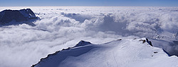
![20070201-DuskSeaOfCloudsPano__ - Sea of clouds on Grenoble as seen from the summit of the Pinea. The Belledonne range sticks out of the clouds on the left.
[ Click to go to the page where that image comes from ]](CPACD5/20070201-DuskSeaOfCloudsPano__.jpg)
Sea of clouds on Grenoble as seen from the summit of the Pinea. The Belledonne range sticks out of the clouds on the left.
[20070201-DuskSeaOfCloudsPano__ - 1563x3969 - AdobeRGB - 1Mb - 6MPix]
Text and pictures © 1992-2026 Guillaume Dargaud
Last updated on 2025/10/27
This CD contains 230 high resolution Climbing pictures provided royalty-free.
Want more information about the CD ?
More info and pictures of Landscape
Sea of clouds on Grenoble as seen from the summit of the Pinea. The Belledonne range sticks out of the clouds on the left.
[20070201-DuskSeaOfCloudsPano__ - 1563x3969 - AdobeRGB - 1Mb - 6MPix]
![20070311-StPancracePano - A panoramic view on the Belledonne range across the Gresivaudan valley while climbing at St Pancrace. Grenoble is in the right part of the valley.
[ Click to go to the page where that image comes from ]](CPACD5/20070311-StPancracePano.jpg)
A panoramic view on the Belledonne range across the Gresivaudan valley while climbing at St Pancrace. Grenoble is in the right part of the valley.
[20070311-StPancracePano - 2683x8421 - AdobeRGB - 3Mb - 23MPix]
Panoramic view of the Belledonne summits behind Chamrousse.
[20070328-ChamrousseBelledone-Pano_ - 2486x8703 - AdobeRGB - 3Mb - 22MPix]
![20071016_174608_MtAiguilleGashVPano_ - Mt aiguille seen from the Selle pass upon reaching the Vercors plateau itself.
[ Click to go to the page where that image comes from ]](CPACD5/20071016_174608_MtAiguilleGashVPano_.jpg)
Mt aiguille seen from the Selle pass upon reaching the Vercors plateau itself.
[20071016_174608_MtAiguilleGashVPano_ - 3670x3670 - sRGB - 2Mb - 13MPix]
![20071016_175618_MtAiguilleZoomPano_ - Sunset on Mt Aiguille, birthplace of climbing 5 centuries ago.
[ Click to download the free wallpaper version of this image ]](CPACD5/20071016_175618_MtAiguilleZoomPano_.jpg)
Sunset on Mt Aiguille, birthplace of climbing 5 centuries ago.
[20071016_175618_MtAiguilleZoomPano_ - 5488x8655 - sRGB - 8Mb - 47MPix]
![20071017_081027_MtAiguilleMorningPano_ - Morning panorama on Mt Aiguille and Grand Veymont from the summit of the Goutaroux.
[ Click to go to the page where that image comes from ]](CPACD5/20071017_081027_MtAiguilleMorningPano_.jpg)
Morning panorama on Mt Aiguille and Grand Veymont from the summit of the Goutaroux.
[20071017_081027_MtAiguilleMorningPano_ - 2782x9739 - sRGB - 3Mb - 27MPix]
![20071017_081226_MtAiguilleMorning_ - East face of Mt Aiguille under an ominous morning sky.
[ Click to download the free wallpaper version of this image ]](CPACD5/20071017_081226_MtAiguilleMorning_.jpg)
East face of Mt Aiguille under an ominous morning sky.
[20071017_081226_MtAiguilleMorning_ - 2848x4256 - sRGB - 2Mb - 12MPix]
Lac Fourchu (forked lake) under the Taillefer.
[20071023_175832_LacFourchu - 2848x4256 - sRGB - 1Mb - 12MPix]
![20071023_180611_MeijePano_ - Part of the Ecrins range as seen from the Taillefer in autumn. The Meije is the leftmost summit. The small but characteristically shaped gash 2/3 into the image is recognizable as the Coup de Sabre, a classic couloir between Pic Sans Nom and Ailefroide.
[ Click to go to the page where that image comes from ]](CPACD5/20071023_180611_MeijePano_.jpg)
Part of the Ecrins range as seen from the Taillefer in autumn. The Meije is the leftmost summit. The small but characteristically shaped gash 2/3 into the image is recognizable as the Coup de Sabre, a classic couloir between Pic Sans Nom and Ailefroide.
[20071023_180611_MeijePano_ - 2205x13229 - sRGB - 3Mb - 29MPix]
![20071023_180846_Meije_ - Meije and Rateau seen from a distance.
[ Click to download the free wallpaper version of this image ]](CPACD5/20071023_180846_Meije_.jpg)
Meije and Rateau seen from a distance.
[20071023_180846_Meije_ - 2848x4256 - sRGB - 2Mb - 12MPix]
![20071023_181742_LacFourchu_ - Meije, Rateau, Girose glacier, Soreiller.
[ Click to download the free wallpaper version of this image ]](CPACD5/20071023_181742_LacFourchu_.jpg)
Meije, Rateau, Girose glacier, Soreiller.
[20071023_181742_LacFourchu_ - 2848x4256 - sRGB - 1Mb - 12MPix]
![20071023_183639_LacFourchu - A view on Grenoble from the Lac Fourchu. City of clouds?
[ Click to download the free wallpaper version of this image ]](CPACD5/20071023_183639_LacFourchu.jpg)
A view on Grenoble from the Lac Fourchu. City of clouds?
[20071023_183639_LacFourchu - 2848x4256 - sRGB - 1Mb - 12MPix]
![20071023_184408_AboveGrenobleVPano_ - View of the Chalets de la Barriere, near the Poursolet. The Vercors is visible on the other side of the valley.
[ Click to go to the page where that image comes from ]](CPACD5/20071023_184408_AboveGrenobleVPano_.jpg)
View of the Chalets de la Barriere, near the Poursolet. The Vercors is visible on the other side of the valley.
[20071023_184408_AboveGrenobleVPano_ - 3994x3994 - sRGB - 2Mb - 16MPix]
![20071208_150939_Moucherotte - A short ski trip on the Moucherotte, barely 20 minutes from Grenoble.
[ Click to go to the page where that image comes from ]](CPACD5/20071208_150939_Moucherotte.jpg)
A short ski trip on the Moucherotte, barely 20 minutes from Grenoble.
[20071208_150939_Moucherotte - 2848x4256 - sRGB - 1Mb - 12MPix]
![20071216-150711_BalconVercors-MtAiguille - The eastern side of the Vercors as seen from the Moucherotte, quite visible are the Mt Aiguille and the Grand Veymont.
[ Click to download the free wallpaper version of this image ]](CPACD5/20071216-150711_BalconVercors-MtAiguille.jpg)
The eastern side of the Vercors as seen from the Moucherotte, quite visible are the Mt Aiguille and the Grand Veymont.
[20071216-150711_BalconVercors-MtAiguille - 2736x3648 - BW - 1Mb - 10MPix]
![20080119_163854_BrokenSpectrum_ - Brocken spectrum seen from Peak St Michel, right below Mt Blanc and the northern tip of the Belledonne range.
[ Click to download the free wallpaper version of this image ]](CPACD5/20080119_163854_BrokenSpectrum_.jpg)
Brocken spectrum seen from Peak St Michel, right below Mt Blanc and the northern tip of the Belledonne range.
[20080119_163854_BrokenSpectrum_ - 2848x4256 - sRGB - 1Mb - 12MPix]
![20080119_163922_FromPeakStMichelP03 - Mirage disturbing the atmosphere of the Gresivaudan valley, in the direction of Mt Blanc.
[ Click to go to the page where that image comes from ]](CPACD5/20080119_163922_FromPeakStMichelP03.jpg)
Mirage disturbing the atmosphere of the Gresivaudan valley, in the direction of Mt Blanc.
[20080119_163922_FromPeakStMichelP03 - 2848x4256 - sRGB - 1Mb - 12MPix]

Complete panoramic view of the Alps from Vercors: Mt Blanc, the Belledonne range, Grandes Rousses (background), Ecrins range (background), Taillefer range and Devoluy.
[20080119_163922_FromPeakStMichelPano_ - 1305x29038 - sRGB - 4Mb - 38MPix]
![20080215_114255_TailleferRangePano_ - The Taillefer range, seen from the Grand Renaud: the Grand Armet on the left and the Taillefer itself on the right, with the Ornon pass underneath.
[ Click to go to the page where that image comes from ]](CPACD5/20080215_114255_TailleferRangePano_.jpg)
The Taillefer range, seen from the Grand Renaud: the Grand Armet on the left and the Taillefer itself on the right, with the Ornon pass underneath.
[20080215_114255_TailleferRangePano_ - 3655x12794 - sRGB - 7Mb - 47MPix]
![20080215_131611_RochailPano_ - Ski tracks on an antecima of the Rochail. On the left are the three Aiguilles d'Arve, then on the right of the Rochail, the Malhaubert point and the Confolens point.
[ Click to go to the page where that image comes from ]](CPACD5/20080215_131611_RochailPano_.jpg)
Ski tracks on an antecima of the Rochail. On the left are the three Aiguilles d'Arve, then on the right of the Rochail, the Malhaubert point and the Confolens point.
[20080215_131611_RochailPano_ - 3236x11329 - sRGB - 5Mb - 37MPix]
![20080215_165602_FromClottousPano_ - The summits circling the Chantelouve valley seen from the Clottous.
[ Click to go to the page where that image comes from ]](CPACD5/20080215_165602_FromClottousPano_.jpg)
The summits circling the Chantelouve valley seen from the Clottous.
[20080215_165602_FromClottousPano_ - 2485x8700 - sRGB - 4Mb - 22MPix]
![20080217_130241_FromGdFerrandPano_ - View from the summit of Grand Ferrand: the Agniere valley, the Bure Peak, Rocher Rond, Charnier Pass, Tete de Vachere (background), Tete de Vallon Pierra, and the Jarjatte valley.
[ Click to go to the page where that image comes from ]](CPACD5/20080217_130241_FromGdFerrandPano_.jpg)
View from the summit of Grand Ferrand: the Agniere valley, the Bure Peak, Rocher Rond, Charnier Pass, Tete de Vachere (background), Tete de Vallon Pierra, and the Jarjatte valley.
[20080217_130241_FromGdFerrandPano_ - 3773x13205 - sRGB - 8Mb - 50MPix]
Panorama of the Tete de Lauzon from Grand Ferrand.
[20080217_134554_TeteLauzonPano_ - 3501x9336 - sRGB - 4Mb - 33MPix]
![20080308_084415_OlanFromLavey - The Aiguille de l'Olan and the Maximin couloir on the right edge.
[ Click to download the free wallpaper version of this image ]](CPACD5/20080308_084415_OlanFromLavey.jpg)
The Aiguille de l'Olan and the Maximin couloir on the right edge.
[20080308_084415_OlanFromLavey - 2736x3648 - sRGB - 2Mb - 10MPix]
![20080313_164437_GrandPrePano_ - Sunset on Grand Pre, Serre Chevalier.
[ Click to go to the page where that image comes from ]](CPACD5/20080313_164437_GrandPrePano_.jpg)
Sunset on Grand Pre, Serre Chevalier.
[20080313_164437_GrandPrePano_ - 3596x7630 - sRGB - 4Mb - 27MPix]