"For scientific leadership, give me Scott; for swift and efficient travel, Amundsen; but when you are in a hopeless situation, when there seems to be no way out, get on your knees and pray for Shackleton." — Sir Raymond Priestley.
RadarSat images © 1997 Canadian Space Agency, used with permission.
Satellites that record optical images are useful for many purpose, but they require clear sky... and sunlight. The canadian RadarSat system, however, can see the surface of Earth in any condition. Also if you look at ice, it just appears white, while the radar beam can enhance irregularities and show diverse terrain types.
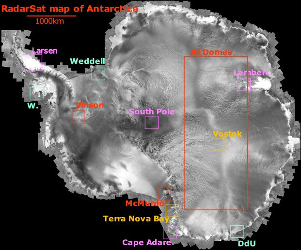
Left: a composite image of many passes of the RadarSat satellite. I got this large image file from the Geophysical Institute of the University of Alaska Fairbanks (where I worked in '95 !) and I processed it with LargeImage, a little freeware I wrote. You can do it yourself easily, but be warned, the download is 1.6Gb ! The little boxes show the locations of the next graphics.
Click here to get a JavaScript animation of:
The RadarSat system is a major improvement over previous maps of Antarctica, first drawn by land or air explorers on only a few selected trails, with all the rest of the continent remaining a desperate blank. The advent of satellites improved our view of the shorelines while the center, all white, flat and out of view of all but the most polar orbits stayed uncharted till RadarSat's mission in 1997.
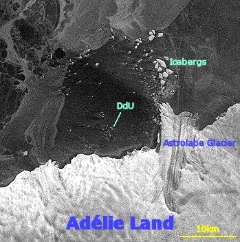
Right: a zoom on Adélie Land centered on the Pointe Géologie Archipelago. Clearly visible are the Astrolabe glacier and several large icebergs breaking away from it. The small islands among which Dumont d'Urville is located are barely visible west of the glacier. 1 pixel=125m.
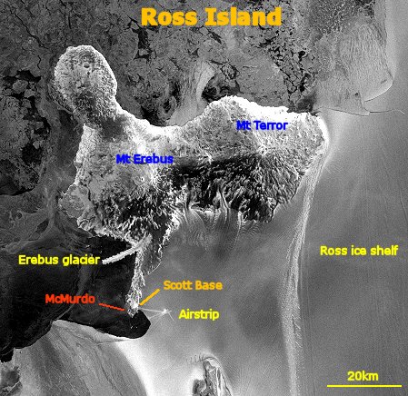
Left: A view of Ross Island on the southern end of the Ross sea. The airstrip is clearly visible on the Ross ice-shelf. Also clearly visible are the two volcanoes Mt Erebus and Mt Terror. Erebus is the only active Antarctic volcano; it is also the largest. McMurdo and Scott Base (New Zealand) are located on the south-west end of the island. Sea ice is clearly visible on the top part of the image. 1 pixel=250m.
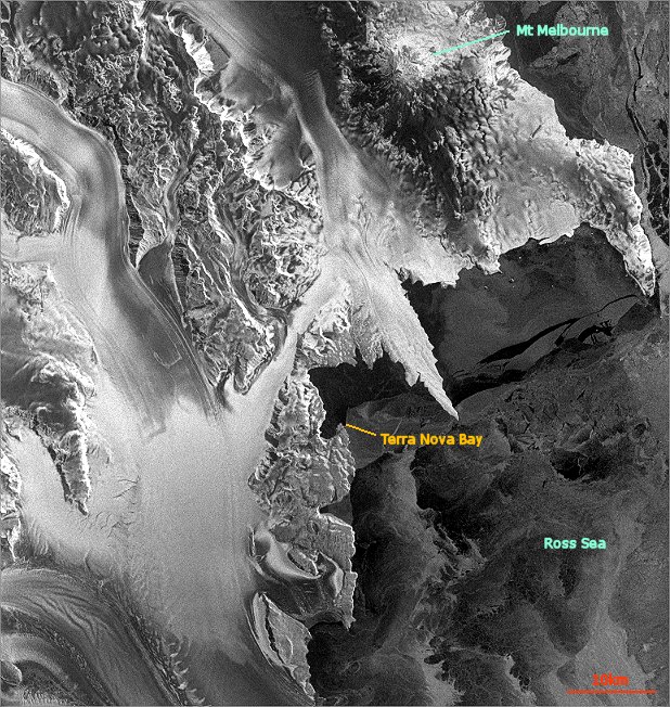
Right: Western part of the Ross Sea. The italian station of Terra Nova Bay is located on the small peninsula on the south end of the bay. The volcano Mt Melbourne (~2500m) is clearly visible on the north part of the picture. The glacier west of Terra Nova Bay is used to land Twin-Otters and C-130 after the sea-ice breaks up during the summer. 1 pixel=125m.
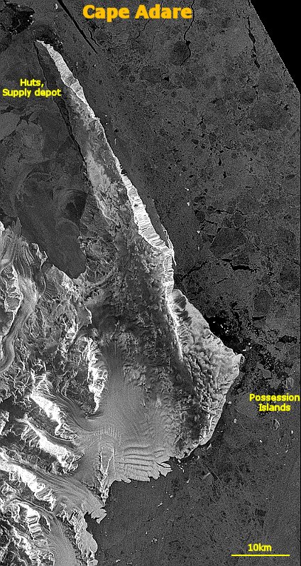
Left: This is a satellite view of Cape Adare and the Possession Islands, a site of historical significance as it was used by early expedition as supply depot, emergency huts and drop-message post. Some remains are still visible, like the grave of Hanson. This cape is on the north-west end of the Ross sea, north of Terra Nova Bay. 1 pixel=125m.
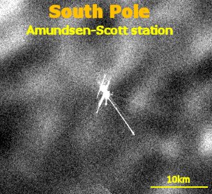
Right: This is a zoom on the south pole itself where the American station of Amundsen-Scott is located. the various buildings, even those that have been underground for years are clearly visible due to the ability of the radar to 'see' through snow. The packed snow of the airfield makes for a good radar reflector. Note that unlike the picture of Vostok below, there is no track leading to the station: the americans airlift everything to the south pole. It's more expensive, harder to organize and more dangerous than land traverses which the Russians have been doing for 40 years at Vostok and the French for 10 years at Dome C. Although in 2003 there's discussion about starting to do the same for South Pole to save money, the main problem being the crossing of the mountain range above the shore. Here's a link to an excellent aerial picture of the south pole station. 1 pixel=125m.
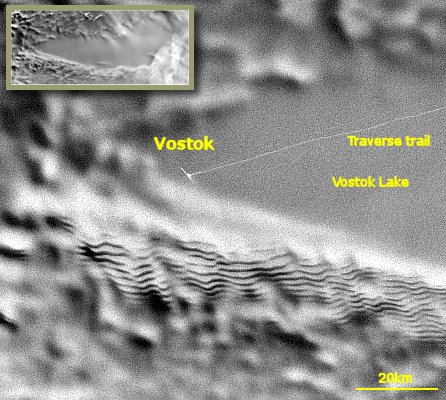
Right: This is a view of the Russian base of Vostok, the place where the coldest temperature on Earth has been recorded at -89.9°C. The trail of the vehicles bringing supplies in summer is clearly visible on the right. Vostok also held for a long time the record of the deepest ice core with a depth of 3623m spanning the past 420 000 years (now beaten by Concordia). Vostok sits on top of about 4 vertical kilometers of ice !
The difference of surface regularity north (right) of the station is striking. The weird lines at the bottom of the picture are snow dunes ripples as large as 100km; their low angled slopes and small height of only a few meters make them all but invisible from the ground. The large smooth area shows the outline of lake Vostok, 250km long but lying 4km under the ice. The station is located on the southern tip of the lake outline (as shown on the inset). At 280km per 50km, lake Vostok is the largest of the 70 known subglacial lakes. The lake has been isolated from the rest of the world for the past 15 millions years, so who knows what awaits discovery in it... The drilling stopped about 30 meters from the lake while decontamination techniques are being thought of. The water stays liquid between ground an ice thanks to a combination of high pressure from above and suspected geothermal activity from below (for instance at the other deep ice core of Dome C, the temperature at a depth of 3130m is -7 °C while the surface ground temperature is -53°C). 1 pixel=250m for the picture, 1 pixel=2km for the inset.
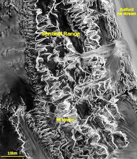
Right: Mt Vinson at 5140m is the highest summit of Antarctica and sought after by the best climbers (well, I'd love to go too...), but it's far inland, on the Trans-Antarctic Range, at the base of the Antarctic Peninsula. Access is done by flying to the blue ice runway of Patriot hills to the south and dragging a sled for a few days from there. 1 pixel=125m.
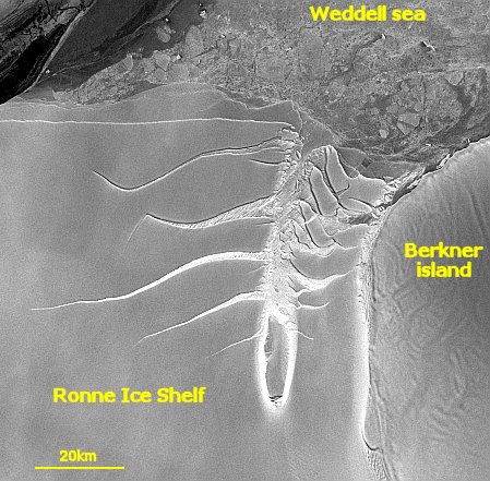
Left: A fracture zone on the eastern side of the Ronne ice shelf, east of the Weddell sea. There is probably a tiny island causing the ice flowing from the south to shear. Cracks expand into the ice which will later form large icebergs as they reach the edge of the shelf to the west (left). 1 pixel=250m.
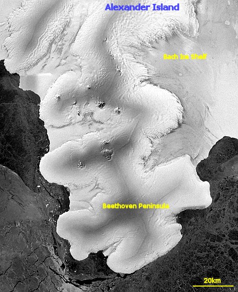
Right: The Beethoven peninsula wriggling west of Alexander Island, carved by the many glaciers of the Antarctic Peninsula. 1 pixel=250m.
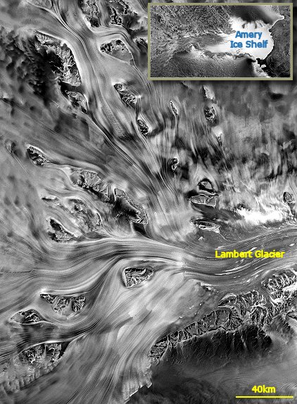
Left: Ice flows like rivers, only slower. On this picture, the Lambert glacier tributaries merge before reaching the Amery Ice Shelf. 40km wide and over 400km long, Lambert is the biggest glacier on Earth, regularly calving gigantic icebergs the size of whole countries. 1 pixel=500m on the picture and 1 pixel=4km on the inset.
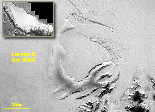
Right: The inset shows the entire Larsen B ice shelf before its disappearance; this ice shelf was east of the Antarctic peninsula. The large image shows ice domes south of the Larsen B ice shelf. This very large layer of floating ice, which had been stable for tens of thousands of years, broke apart and disappeared in a few weeks in 2002. One more sign of global warming ? Most likely, yes, read the Antarctic climate FAQ. 1 pixel=250m on the picture and 4km on the inset.
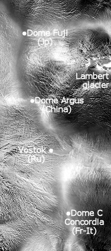
Left: a view spanning most of the high plateau of eastern Antarctica. The 'ridge' of domes is visible running vertically on the image. The lighter color comes from the fact that there is less wind on the domes, so less surface irregularities (sastrugi), and therefore it reflects the radar beam differently from other areas. The domes are areas of specific interest for studies of atmosphere physics, glaciology and also astronomy for the highest ones.
Want to see more ? Well, I have a cgi-script that can do some of that stuff for you. I just hope it's not going to get too many requests as it is pretty I/O intensive and hosted on a slow line.
I have more satellite pictures of Antarctica taken by a Weather Satellite.
For some other samples of satellite pictures of ice, go to the origin of it all: NASA itself.
