"We had bad winds at Cape Evans this year, and we had far worse the next winter when the open water was at our doors. But I have never heard or felt or seen a wind like this. I wondered why it did not carry away the Earth." — Cherry-Garrard.
Atmospheric science experiments
Right: Sodar in action at DdU.
The sodar was one of two experiments I installed and ran during the winter '93. Each antenna emits a 1/10th of a second 'beep', at frequency 1750Hz, 2000Hz and 2250Hz, every 6 seconds (similar to what you hear right now if you have the sound on). The echo of the sound is then analyzed and we can deduce the wind speed and direction up to a height of 900m in good conditions (low wind and low turbulence). This is used to study boundary layer meteorology.
The adelie penguins seen in the foreground were so noisy that they were interfering with the measurements, but they are present only in summer. Well, maybe we were interfering with their sleep too, but they never complained and came back the following year...
Left: Automatic Weather Station (AWS) of Dome C.
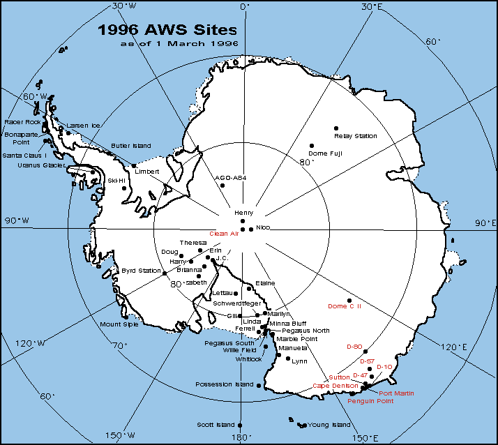
This is the other experiment I worked on during the winter. We installed a satellite antenna to receive data from AWS via the NOAA satellites. There are about 70 of those stations on the continent and they broadcast the wind speed, wind direction, temperature, pressure and humidity every 10 minutes. They are solar powered, although a few of them used to be nuclear powered (no sun in winter in the center of the continent). There was one at D-10, about 10 km away from DdU, one at D-47, at D-80... But several broke down during the winter, probably due to harsh wind conditions. They get repaired regularly. Check the map of the operational AWS stations, below.
Right: Tethered balloon at DdU.
This helium balloon was used for a few days in 94 by my boss, Stefania Argentini, to check the results of the Sodar. The wind was often so violent that it was just plain impossible to launch it (or to retrieve it, we lost one !).
Right:
Those radiosondes are used to determine the wind speed and direction at higher altitude, as well as the altitude of the 500hPa isobaric layer. The probe attached under the latex balloon sends its data and GPS position to a ground station by radio while the balloon goes up. At some point it pops, fall down to earth and is lost. Similar balloons are launched all over the world at the same time twice a day as part of a worldwide effort by national weather forecasting services; results are then transmitted and integrated in computer models used for your daily weather forecast.
Right: VHF radar at the rocket launch building.
The old rocket launch facilities of the '50s was the site of our '98 radar experiment. You can see the radar deployed in front of it as an array of 16 small antennas. The electronics controlling the acquisition are in the orange shelter. We had some trouble with the electronics: burnt amplifier, radio noise... If you are interested, you can read about our preliminary results.
Left: Building destroyed by the wind.
When a storm hits, things seldom get out of hand because we are used to it and because everything that can fly away has already flown off... But during spring '94, there was a gap in the iceberg strip usually protecting the station from the fiercest winds. A big storm hit and the waves had enough distance to form and gather momentum through the gap. Big waves hit the side of the just-completed airstrip, throwing 30cm rocks and chunks of ice 30m up in the air. Some of those landed on the buildings of the airstrip. You can see the result here, a building destroyed like paper...
Antarctic Climate FAQ
Why is it important to study Antarctic climate ?
The Antarctic continent has two main roles with global climate: it's the area of the Earth with the most important heat loss towards space, and also the Antarctic ice sheet acts as a long term water storage system in the global water circulation. Antarctica also plays a role in atmosphere and ocean circulation and thus needs to be taken in account by global models.
How's the weather observation network organized ?
There are 45 permanently manned stations on the 7th continent, most of which have weather forecasting personnel, 15 of those perform balloon launches and thus can provide vertical profiles of the atmosphere. There are also about 70 automatic weather stations covering the Antarctic continent, sending their ground data via satellite every 10 minutes. And since the 60s there are also polar orbit satellites which return various kinds of atmospheric remote sensing informations or imagery at multiple wavelengths. The density of observatories is actually the same than on some of the other continents despite all the logistical difficulties.
Does it ever rain in Antarctica ?
On the central high plateau, it never rains as the summer temperature never even reaches -10°C even at the height of summer. But in the peninsula or other places on the coast, you can get wet snow or even rain. More rarely there can be freezing rain: water that is actually well below freezing temperatures and that turns to ice instantly when it touches the ground. During one such episodes at Dumont d'Urville, several people fell on the slippery ground or passageways and hurt wrists or arms.
How can you determine what the global atmospheric temperature was thousands of years before written records were kept ?
It's called radiochemistry and is performed mainly on ice cores drilled thousand of meters down (but also on ocean sediments core). For example the isotopes of interest for temperature determination are deuterium (D, a heavy version of hydrogen), as well as oxygen-18 (a heavier version of the normal oxygen-16). Water vapor turns to precipitation over the polar ice sheet more readily when it has the composition HDO or H218O than if it is normal water, H2O. As air cools above the poles, water changes phase from vapor to liquid or ice, thus losing D and 18O preferentially. This means that the coldest snow has the least D and 18O in it. Measuring those concentrations in ancient ice is enough to evaluate past global temperatures.
As for determining past CO2 levels, those are measured directly in trapped air bubbles in the ice. Thus a strong concordance between global temperature and CO2 level have been found.
Now that the Epica project has finished drilling and stopped a few meters short of bedrock, why is there still some glaciology research at Dome C and how is it different from the drilling ?
It's still hard to tell. Scientists have studied Antarctica for barely more than a century and have been continuously monitoring temperature down there only for the last 50 years, not enough to get significant statistical variations. Some areas seem to get warmer while others seem to get colder, most of which comes probably from our lack of older data.
In the early 2000s there has been an unusual number of very large icebergs separating from Antarctica, but since satellites have been watching the area for barely more than a decade, it's hard to decide whether it's unusual or not. More striking was the collapse and disappearance of the Larsen B ice shelf, a large layer of floating ice located in the Antarctic peninsula which broke apart and disappeared in less than a month in 2002. The ice constituting it was tens of thousands of years old and the speed at which it was gone astounded every researcher ! This floating ice, which was far from being as thick as the rest of Antarctica, started melting on the surface, with water running down the gentle slope from the peninsula, carving up thin crevasses. Then when the crevasses reached all the way through to the sea below, it broke apart in large chunks which separated, lost balance and spread away on ocean currents. That was it. A forerunner of global warming disaster ? Maybe, but maybe not: this area, farther north than the rest of Antarctica, is very sensitive to such dramatic climate variations and breakups like that are likely to have happened in the past.
But 'global warming' does not mean that it warms up everywhere. There might be more precipitation (snow) in parts of Antarctica, more clouds because there's more evaporation from a warmer sea, and it can actually get colder in other parts because of overcast skies. Depending on a cloud's altitude and type, it can trap the sunlight and increase temperature below or on the opposite it can reflect sunlight in space and thus make surface temperature colder. Still too early to tell although a lot of work is currently going on, both theoretical and experimental, putting systems like the meteoflux in action.
In 2020, a temperature of 20⁰C (yeah, that's +20) has been recorded in Antarctica for the 1st time...
Right: Concordia after a couple hundred years of global warming ?
How much would sea level rise if Antarctica melts off ?
It depends on which ice melts. Floating ice (such as North Pole ice cap) doesn't raise sea levels when melting, but land ice such as Antarctica and Greenland does. In first approximation, this assumes the water densities are the same (but glacial ice is freshwater and so melts to a lower density than saltwater) and that the melting of the ice doesn't impact the temperature of the water enough to influence its density. Thermal dilatation of the oceans will actually contribute more to raising sea levels than melting ice. The problem is not as simple as it seems.
Most of the ice of eastern Antarctica lies on rocks above sea level, and that's a lot of it, as thick as 4.8km between Vostok and Dome A. If this ice were to melt off, it would raise sea level by an estimated 200 meters, far from the kilometers imagined in the ridiculous Waterworld movie, but enough to wipe out all coastal areas in the rest of the world. A country like Bangladesh would disappear underwater, as would New-York and most of the tiny Pacific tropical islands. Looking at the sheer amount of ice involved, this probably wouldn't happen suddenly... but looking at what happened to Larsen-B ice shelf, I'm not so optimistic. Note that since the last ice age 12 thousand years ago, global sea level has been on a continuous rise.
"Day After Tomorrow was as much about global warming as Independence Day was about gay rights." — Silellak.
And while I'm talking about movies, The Day after Tomorrow in all it Hollywoodiness catches on a few interesting points. For instance the Larsen B ice shelf shown at the beginning broke down and disappeared in less than a month in 2002; and we are talking about an area roughly 400x200 km. The Vostok and Epica ice cores show that in the past there have been sudden temperature changes, the record seems to be -14°C in less than 10 years on a global scale; okay so it's nowhere near the timeframe shown in the movie ('a week') but the results would be just as devastating. Note that before and after an ice age, there's a period of instability while the weather patterns shift to new modes and that's when those sudden changes happen. The 'freeze all' eye of the storm you see in the movie is all but impossible: the higher atmosphere has typical temperatures of -60°C and when there's no wind (like in the movie) I can walk around for 5 minutes dressed normally at this temperature, and much more if dressed warmly; also bringing down low pressure cool air from high up would warm it by adiabatic process. More interesting is the correct fact that global warming can trigger changes in ocean currents leading to quick widespread changes; there is evidence in ocean sediments that when raising temperatures melt the Greenland ice sheet, the amount of freshwater on top of the ocean is enough to stop the flow of the Gulf Stream, sending european temperatures plummeting down. Yes, global warming can lead to much cooler temperatures in some parts of the world (but not at all like the movie shows). All in all, I thought it was a movie with some, let's say, 'interesting' atmosphere science 'facts'.
I read that some scientists say there's no such thing as global warming...
... or what about the other side in the global warming debate ?
The treatment of Global Warming in the media is done in a biased way in the sense that they often present both sides' viewpoint. The fact is, there IS NO OTHER SIDE. The scientific evidence that humans are affecting the climate with CO2 is as clear as day, and scientists who say otherwise are hired by special interest groups or oil companies. The media do the issue a great disservice by trying to be fair and covering both 'sides' of the issue. We NEED to be concerned.
Want to understand how the media are misrepresenting the issue ? Set an hour aside and watch this.
To sum it up (a) human activity is having an effect, (b) we are observing medium term temperature changes since 1700 and (c) natural causes and cycles (solar cycle, 1200 year cycle) are having an effect. The consensus is that (a) and (b) are connected. For sure there are scientists, some prominent, who claim that the there's no connection, but even those do not disagree with (a) and (b) themselves. The disagreement is on the weight to assign to natural and human causes. Worse, activists on both sides try to pretend that it is either all human activity or all natural causes. The truth is not out there, it's in between.
And even if you won't consider the warming itself, here's some more information: (1) Global atmospheric CO2 levels are increasing; (2) CO2dissolves in the oceans; (3) When CO2 dissolves in water the pH of the water goes down (becomes more acid); (4) When the pH of the water goes down, Calcium Carbonate concentrations go down; (5) When calcium carbonate levels go down the plankton dies; (6) When the plankton dies, so does everything else by starvation; (7) So, SUV or killing your own species ?
And for those who think that global warming is 'bullshit', did you know that bovine flatulence is a major source of atmospheric methane, a major greenhouse-effect gas ? C;-)
More seriously, for a good miniature ecological end-of-the-world scenario that happened, go read up on Rapa Nui, aka Easter Island. Would you like to prevent something like that, summarized as the Tragedy of the Commons, from happening ?
I haven't heard much about the ozone hole lately. What's the status ?
As of early 2005 the ozone hole is back to about the size it had when it was discovered 20 years ago. There's still a lot of chlorine and bromine chemicals high up in the atmosphere but since they were banned a few years ago, there seems to be a stabilization of their concentration. So hopefully they'll start to decline from now on and the ozone hole will start to close. Proof that human laws can have an impact fairly quickly.
Unfortunately the measurements taken during the 2005 winter over Antarctica showed that the ozone hole that winter was the most extensive ever. Want a career suggestion ? Dermatologist in Australia... The ozone is measured directly from balloon launched from Antarctica, or indirectly from satellite. In Dome C we launch two kinds of balloons: classic weather probes and astronomy turbulence measurement probes but unfortunately for the first year of operation we don't have the equipment to do ozone soundings.
Why don't you give windchill temperatures on your site ?
Because it doesn't have much meaning. Windchill is supposedly the equivalent windless temperature with the same heat loss for a human body. The problem is that this heat loss depends completely on what you are wearing. You can compute the windchill for someone naked, someone wearing Jeans and T-shirt or someone wearing 15 layers of Antarctic clothing. A better value would be the thickness of clothing required to have an equivalent heat loss.
The term 'wind chill' goes back to the Antarctic explorer Paul Siple in 1939. He conducted experiments on the time it takes to freeze a cylinder of water and found it dependent on the temperature and the wind speed. His formula was later refined by Court and Steadman. Since 2001 the US weather service uses a new formula, but many other countries don't bother with wind chill (it's used almost only in the US). The present formula, in °C and m/s, for wind speed > 1.34m/s is Twc = 13.127 + 0.6215.T + ( 0.48628.T - 13.947 )*Speed0.16
Right: The author, frozen alive while studying the Antarctic climate.
What is a temperature inversion ?
Normally the temperature decreases as you gain altitude ('it gets colder higher up'). In the case of a so-called temperature inversion, you have a cold ground with a cold layer of air directly on top of it and then the temperature gets warmer higher up; then further up it gets colder as expected. This is a common situation in mountain valleys for instance, but also typical at Dome C where the temperature can raise 10°C in no more than 30 meters. Inversions of 25° have been recorded there. The lower cold part is called the inversion layer; and there are various reasons why this situation occurs. One characteristics of inversion layers is that they trap fog and pollutants, which you can notice as a red haze over a city when seen from a nearby mountain or overflying airplane. At Concordia this was typically seen as the smoke from the generator raising vertically from the exhaust and then bending 90° after a few meters, all staying under the layer.
Carbon Dioxide freezes at -70c, so do you see carbon snow falling down the sky at extreme temperatures ?
When you mix water and alcohol, the water doesn't separate and freeze as soon as you go below 0°C. It happens at some temperature in between the two freezing temps (actually it's a lot more complicated than that, see azeotropes. It's the same with the mix of nitrogen, oxygen and CO2 we call 'air', so there's no risk to see flakes of CO2 fall off the sky.
If you want to see dry ice (the other name for solid carbon dioxide) falling from the sky, you have to make it to Mars where the higher CO2 concentration makes it possible.
When did Antarctica start icing up ?
When what would become Antarctica was still part of the Gondwana supercontinent, the ocean currents were much different and carried heat to the poles; so even though Antarctica was already far south, it wasn't cold yet. This was up to 250 million years or so ago, when the dinosaurs were just getting started; so they were roaming the luxurious temperate forests of Antarctica at the time (fossils have been found).
It is estimated that it started covering with ice at the end of the Permian, about 248 million years ago. Note that a major mass extinction of biodiversity happened at that same time all over the world: 90-95% of marine species became extinct (including the Trilobites).
But that was temporary; the polar ice caps melted for a while after that and it wasn’t until Africa and Antarctica separated around 160 million years ago that it began to cool again, on and off.
Then when Antarctica split off from Australia about 50 million years ago, things started to cool in earnest. It first started with glaciers on mountains, and 23 million years ago Antarctica was mostly covered with icy forest.
Then during the Miocene (14 million years ago) an arid cold climate settled in and ice started to accumulate slowly. There were probably some warm episodes where the ice melted off, but then it froze up for good and completely, and ice started piling up with hardly any limit.
Has Antarctica always been so cold ?
Well, it's been cold for a long time, but everything is relative. The ice extracted from Epica ice core at Dome C can be dated back to about 850 000 years ago, but Antarctica had been cold much before that. At the time of the dinosaurs (which ended 65 millions years ago), Antarctica was much warmer, harboring forests and animals whose fossils have been found in various parts of the continent. The reason is twofold: the earth was warmer as a whole, and the shape of the continents was different, with Antarctica farther north close to what is now Australia. Plate tectonic activity pushed it further south where it started getting colder and accumulating ice.
This ice has been accumulating for so long that the sheer weight of the ice, kilometers deep of it, has lowered the altitude of the bedrock, often sending it under sea level. Areas like northern Canada used to have such a thick layer of ice on top which melted at the end of the last ice age about 10 thousand years ago; and now the surface rid of this weight is slowly raising up (this is called an isostatic rebound and can be measured precisely).
The pressure from all this ice, combined with the thermal flux coming from the center of the Earth, slowly melts the ice at the bottom so the ice moves both horizontally in glaciers and vertically by melting. There are mysterious sub-glacial lakes and river systems kilometers deep under the ice that slowly carry away the water resulting from this melting process.
The biggest glaciers in the world are located in Antarctica, flowing from the center (the domes) towards the coast. The biggest glaciers are thousands of kilometers long and hundreds of kilometers large, periodically spewing forth icebergs as big as countries like Switzerland.
What's up with -53°C ?
It's the average temperature at Dome C. It's also, logically, the temperature of the snow at Dome C if you go more than 5 meters deep where the yearly variations don't show anymore. Incidentally, it's also the average temperature on Mars...
Right: A frozen radiometer, used to measure solar intensity above Antarctica.
What about this recent theory that Scott's ill fated south pole expedition failed due to exceptionally bad weather ?
Who knows... This theory is based on very limited weather data measured on the coast, so on only one point and far from the expedition itself. All I can say is that it didn't seem to affect Amundsen, now did it ? And since Scott had no way to know what kind of weather to expect inland, you can still blame the failure on piss poor preparation. Why Scott is still revered in most of the world after having failed and killed his crew while Amundsen is mostly ignored although he was the first at both poles is beyond me. Better P.R. I guess.
What about the "anomaly" two miles beneath the ice that could be a man-made structure ?
Short answer: made up bullshit.
Long answer: use a bit of common sense, people, and stop asking about things you read in the National Inquirer or other garbage websites. This 'news' surfaced on conspiracy websites in late 2005 (and will no doubt be forgotten as soon as the next face on Mars or some such is 'discovered'). To give a more constructive criticism, consider that it took 8 years to build Concordia station on the surface; for the upgrade of South Pole station (one building) it took up to 5 C-130 flights every day during every summer campaign for several years; and to drill a simple 20cm hole 3km deep into the ice it took 20 years for the Russians and more recently 8 years for the Europeans. Now do you still think that anybody could build 'something' 3 km under the ice without anybody noticing ?!? Technically it's just plain impossible. As for the logistics involved, with McMurdo working as a logistical hub for Antarctica, how do you explain that none of the hundreds of workers have heard of this, even though it's enough to offer them a beer upon their return in Christchurch to know all about the dirty laundry of the NSF and Raytheon management...? BTW, we already have plenty of radar images of the Antarctic bedrock and they don't show anything funky. And final nail in the coffin of this rumor: nobody has seen these so called 'pictures'.
No, I won't link to the website carrying this 'news' as I don't want to give them any publicity. They can't even get their facts right: ice hasn't started covering Antarctica 12 thousand years ago, just an error by a factor 4000, no big deal since I guess the kind of people who spreads those 'news' probably think it started icing up just after 'intelligent design' started. Yes, I can't stand such an extend of either sheer stupidity or attempt at exploiting stupidity.
How many poles are there in Antarctica ?
This is a much better question than you'd expect...
The geographic pole, commonly known as south pole, is where the axis of rotation of Earth comes through, where all the meridians lines of the maps converge, where the day lasts 6 months and the night lasts 6 months, where Scott and Amundsen raced in 1912 and where the American research station 'Amundsen-Scott' is located.
The magnetic pole is where the black needle of your compass points to. Entire groups of researchers try to understand how the Earth creates its magnetic field, and particularly why the magnetic poles move so much. In 1950 it was 150km inland near Adelie Land and the French built the tiny Charcot Research Station to study it (a station which was soon buried in the snow and consequently lost). In the late 80s the magnetic pole drifted a few kms from Dumont d'Urville and now it is 50 km away in the sea. The magnetic poles invert periodically (every 100 000 years or more). Confusingly the south magnetic pole is actually the same 'pole' as the north pole of any magnet... see if you can figure out why.
The geomagnetic pole, located somewhat between the magnetic and geographic pole, is harder to define. The Earth is surrounded by a magnetic field that extends far away in space and protects us from the solar radiations. This layer converges on the Earth at the geomagnetic poles. You can also consider it as the true axis of the 'magnet Earth' (the dipole equivalent). It is approximately 1200 kilometers from the south pole, close to Vostok Station (roughly halfway between geographic and magnetic pole). The maximum amount of auroras tend to happen on a 1000km radius circle centered on this pole.
The inaccessibility pole is the point of Antarctica that's the farthest away from any coast, making it the hardest point to reach. It is not a true pole in the sense that one can define the same thing for, say, the USA or any continent.
The pole of the cold is the coldest area on the planet, somewhat between Dome A (highest dome of Antarctica), the south pole and the inaccessibility pole. Temperatures may reach down to -100°C in winter, but no one has ever gone in those parts, with good reasons ! Actually in 2013 NASA scientists studying various satellite data of the last 3 decades from the area determined a cold weather record for the planet in those parts at -93.2°C. Now we are talking. Why is it colder than the slightly higher Dome A ? Because there the cold air pools instead of sliding down the slope and keeps radiating whatever remant heat it has towards the sky, hence getting increasingly colder.
All those poles have counterparts in the northern hemisphere, but not necessarily on the exact opposite side of the planet.
How is Antarctica being polluted ?
Directly and indirectly. Directly by human activity near the research stations: exhaust fumes from engines, garbage piling up, leaking fuel tanks, ships crashing into rocks in unchartered waters, alien germs contaminating local animals... All those have happened and although expedition organizers are more environmentally aware than most people, problems still happen every once in a while. The Antarctic Treaty set up a lot of rules for garbage elimination for instance, and there are sometimes cross-inspections from members of the signatory countries.
Indirectly by atmospheric contamination coming from other parts of the world and carried there by high altitude air transfers. This is actually a good thing for science: by analyzing the air or recent ice samples in Antarctica, one can have a clear picture of what the average state of the world is, without local interference. Antarctica is the greatest laboratory for atmospheric chemistry. And since the snow accumulates each year, it traps deep into its ice a record of past atmospheric contents.
The high polar plateau stations like South Pole or Dome C all have a restricted area where travel by machine is forbidden. Those areas, usually located upwind from the stations are where atmospheric chemistry experiments are conducted.
Let me tell you that it doesn't take much to pollute Antarctica. In Dome C we melt the snow to obtain water, but even if taken hundreds of meters upwind from the base, the water tastes like gasoline when not filtered.
Why should Antarctica be protected ?
I'll give a cynical answer to that one: because it's easy and cheap ! There are basically few restrictions necessary and they don't piss a lot of people off like protective measures in the rest of the world (think Arctic Drilling for instance).
Does the Piri Reis map really show Antarctica ?
I'm not qualified to answer that (I have some difficulty reading 15th century turkish written in arabic, who knows why...), so I'll refer you to what I think is the best explanation (and debunking) here.
On this table figures the official weather data taken in Dumont d'Urville during the year 1993, month by month, along with the averages and records since the station started operating (1953).
As you see, DdU is quite warm for Antarctica (-37.5°C at the coldest)... but is really the windiest place on Earth (324 km/h). Tornadoes are faster still but do not last as long: an episode of strong katabatic wind can last more than ten days, never getting below 150km/h.
Year 1993
Jan
Feb
Mar
Apr
May
Jun
Jul
Aug
Sep
Oct
Nov
Dec
Average temperature (°C)
0.3
-3.6
-8.4
-13.5
-16.7
-19.4
-16.1
-15.1
-15.5
-13.5
-7.0
-2.6
Norm 1961/1990
-0.7
-4.2
-8.8
-13.2
-14.8
-15.9
-16.2
-16.7
-15.5
-13.3
-7.0
-1.8
Absolute Min Temp
-5.6
-15.5
-17.7
-24.2
-28.0
-31.7
-30.2
-26.4
-24.9
-25.7
-17.9
-11.3
Records 1956/1992
-10.5
-15.5
-23.3
-29.3
-32.3
-33.4
-35.7
-37.5
-36.8
-31.5
-22.4
-12.8
Absolute max temp
6.0
6.5
3.4
-5.2
-8.0
-5.3
-2.9
-2.1
-4.0
-0.8
-0.2
4.5
Records 1956/1992
9.1
5.3
3.1
1.1
2.8
1.1
3.2
0.4
0.8
0.2
5.5
8.1
Average pressure (hPa)
993.5
988.1
988.5
987.8
981.5
982.2
981.4
976.4
983.9
978.4
980.7
985.8
Norm 1961/1990
991.8
988.9
986.7
987.7
990.7
992.3
990.9
988.3
983.2
983.1
986.1
990.2
Average Humidity (%)
50.2
66.5
60.8
60.2
61.3
53.3
67.1
69.1
65.5
66.9
65.7
70.5
Norm 1961/1990
36.1
58.6
60.5
62.2
62.8
64.4
66.9
65.9
65.4
57.2
55.6
61.8
Sunlight (hours and tenths)
168.9
225.9
136.5
87.4
19.5
0.0
4.0
47.5
115.6
227.5
220.8
193.9
Norm 1961/1990
287.7
207.0
169.3
110.7
46.9
10.0
21.5
74.7
142.4
264.3
324.6
359.7
Snowfall duration (h)
34.1
66.5
73.4
60.9
40.8
28.9
138.1
101
95.9
38.1
58.1
94.5
Norm 1961/1990
44.4
45.2
56.2
47.3
50.6
55.8
77.7
72.1
63.5
43.0
38.3
37.0
Numbers of days with snow
8
8
12
11
13
5
15
18
12
6
10
13
Norm 1961/1990
8
8
9
8
8
8
11
11
9
7
6
7
Nb of days with blowing snow
1
2
12
9
10
5
12
13
11
9
5
3
Norm 1961/1990
0
2
4
5
7
7
9
10
9
5
2
0
Nb of days with blizzard
1
2
4
4
5
2
6
8
7
3
4
1
Norm 1961/1990
0
1
2
3
4
4
6
7
6
4
1
0
Max wind speed (km/h)
151
169
220
205
184
162
173
159
151
137
166
122
Records 1956/1992
230
245
245
252
248
230
259
295
263
252
245
Nb of days with wind>100 km/h
13
8
9
10
12
12
9
14
10
11
11
8
Norm 1961/1990
7
11
13
13
13
13
12
14
14
11
9
9
The AWS station is located near D-10 on the map below, about 10km from DdU. D-10 serves as a continental starting point for the expeditions going to Dome C in summer.
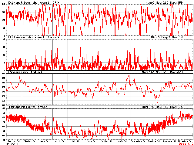
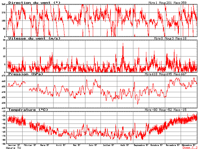
Weather report for Dome C, 1994
AWS data taken in 1994. Argos number 8904, Latitude 74.50S, Longitude 123.00E, Altitude 3260m.
Mon
Mean air temp (°C)
Max air temp (°C)
Min air temp (°C)
Mean wind speed (m/s)
Wind direction (°)
Max wind speed (m/s)
Mean air press (mb)
Max air press (mb)
Min air press (mb)
Jan
-28.6
-16
-45
3
178
8
653.9
666.1
646.9
Feb
-41.8
-17
-57.9
1.9
227
6
646.5
653.9
640.4
Mar
-55.7
-29.6
-69
2.4
234
9
639.3
647.8
627.5
Apr
-60.7
-44
-71
2.4
180
9
642.9
658.7
629.6
May
-65.2
-31.2
-80
2.9
239
12
638.3
663.4
626.7
Jun
-61
-41.9
-77.9
3.1
200
11
656.4
669.8
631.4
Jul
-60.7
-37.8
-73.2
2.6
183
10
645.4
659.8
634.3
Aug
-67.8
-46
-80
1.8
192
7
633.1
647.5
616.9
Sep
-56.5
-29.6
-75.6
2.5
191
10
644.6
669.3
626.5
Oct
-50.6
-31.4
-67.1
2.8
179
12
639.4
660.9
628.8
Nov
-38.2
-13.4
-62
2.3
189
10
648.1
656.1
640.1
Dec
-31.3
-17
-44.5
2.2
169
8
645.9
655.5
639.3
Mean
-51.5
2.5
197
644.5
Seen in a graphical way, here is are 2 graphics for Dome C, in 1996 and 1997. It's easy to tell summer (sun 24 h/day), spring/autumn (alternating sun and night) and winter (dark all day). The Concordia station is supposed to open for winter over sometimes after 2000. I don't know who's going to go there, but it's going to be pretty tough to survive the winter: cold and isolation are going to take their toll.
All AWS data for hundreds of stations since 1980 can be found at the following site: http://uwamrc.ssec.wisc.edu/aws/awsproj.html.
In addition, there is some cold humor there, but the site has not been updated in ages.
So what is the weather like, right now, in Antarctica ? Here are some external links:
![[SodarDdU.jpg]
Sodar in action at DdU.](Sky/SodarDdU.jpg)
![[AwsDC.jpg]
Automatic Weather Station (AWS) of Dome C.](DomeC/AwsDC.jpg)
![[BaloonDdU.jpg]
Tethered balloon at DdU.](Sky/BaloonDdU.jpg)
![[Balloon.jpg]
Francis launches the daily balloon from Dumont d'Urville.](Sky/Balloon.jpg)
![[HallFusee.jpg]
VHF radar at the rocket launch building.](DdU/HallFusee.jpg)
![[WindDestroy.jpg]
Building destroyed by the wind.](DdU/WindDestroy.jpg)
![[GlobalWarming.jpg]
Concordia after a couple hundred years of global warming ?](DC2005/GlobalWarming.jpg)
 Waterworld movie, but enough to wipe out all coastal areas in the rest of the world. A country like Bangladesh would disappear underwater, as would New-York and most of the tiny Pacific tropical islands. Looking at the sheer amount of ice involved, this probably wouldn't happen suddenly... but looking at what happened to Larsen-B ice shelf, I'm not so optimistic. Note that since the last ice age 12 thousand years ago, global sea level has been on a continuous rise.
![[FrozenGuillaume.jpg]
The author, frozen alive while studying the Antarctic climate.](DC2005/FrozenGuillaume.jpg)
![[20050321_12_RadiometerDeposit.jpg]
A frozen radiometer, used to measure solar intensity above Antarctica.](DC2005/20050321_12_RadiometerDeposit.jpg)