Text and pictures © 1993-2026 Guillaume Dargaud
Last updated on 2025/10/27
"Polar exploration is at once the cleanest and most isolated way of having a bad time which has been devised... There are many reasons which send men to the Poles, and the Intellectual Force uses them all. But the desire for knowledge for its own sake is the one which really counts and there is no field for the collection of knowledge which at the present time can be compared to the Antarctic. Exploration is the physical expression of the Intellectual Passion. And I tell you, if you have the desire for knowledge and the power to give it physical expression, go out and explore. If you are a brave man you will do nothing: if you are fearful you may do much, for none but cowards have need to prove their bravery. Some will tell you that you are mad, and nearly all will say, 'What is the use?' For we are a nation of shopkeepers, and no shopkeeper will look at research which does not promise him a financial return within a year. And so you will sledge nearly alone, but those with whom you sledge will not be shopkeepers: that is worth a good deal. If you march your Winter Journeys you will have your reward, so long as all you want is a penguin's egg." — Cherry-Garrard.
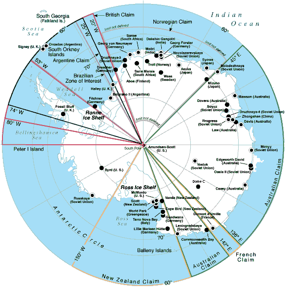
Map of Antarctica showing most of the research stations past and present. Some stations are very small, only a shelter or two and are seldom, if at all, used any more.
Very few of those are active in winter; among them are McMurdo, Scott, Dumont d'Urville, Casey, Mirny, Davis, Mawson, Syova, Neumayer... (the only continental ones open in winter are South Pole, Vostok and in 2004 Dome C). Stations located in the peninsula are not shown here but there are many of them.
Links to maps from the SHOM:
The information shown below is from the 1995 CIA World Factbook, available on various Internet sites. It's not like I'm going to go to Antarctica with a tape to measure the surface area or anything...
Location: continent mostly south of the Antarctic Circle.
Map references: Antarctic Region.
Area: total area: 14 million sq km (est.), land area: 14 million sq km (est.), comparative area: slightly less than 1.5 times the size of the US, note: second-smallest continent (after Australia).
Land boundaries: none, but see entry on International disputes.
Coastline: 17,968 km
Maritime claims: none, but see entry on International Disputes.
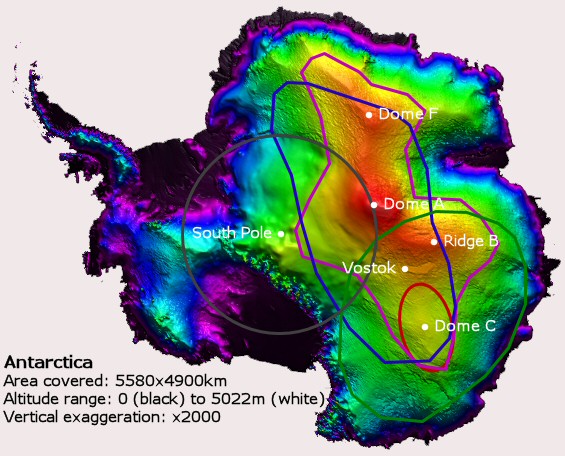
Right: Another antarctic map, derived from RadarSat data, showing a colored topography of the continent. Black is altitude 0, white is 5022m and it goes from purple to red in between. The various domes are fairly obvious. The center of the map has a lower resolution due to lack of satellite data. Various areas of interest are colored on the map showing the extraordinary interest of Dome C for science: Altitude > 3000m, Slope < 1/1000, Snow accumulation <5g/cm2/year, Auroral oval below the horizon, Limit of visibility for geostationary satellites. So in short it combines a high altitude, a very flat terrain, a very low snow accumulation (and good weather), an absence of light and the possibility to reach geostationnary satellites. Note that it's the only research station combining all those.
International disputes: Antarctic Treaty defers claims (see Antarctic Treaty Summary below); sections (some overlapping) claimed by Argentina, Australia, Chile, France (Adelie Land), New Zealand (Ross Dependency), Norway (Queen Maud Land), and UK; the US and most other nations do not recognize the territorial claims of other nations and have made no claims themselves (the US reserves the right to do so); no formal claims have been made in the sector between 90 degrees west and 150 degrees west.
Climate: severe low temperatures vary with latitude, elevation, and distance from the ocean; East Antarctica is colder than West Antarctica because of its higher elevation; Antarctic Peninsula has the most moderate climate; higher temperatures occur in January along the coast and average slightly below freezing.
Terrain: about 98% thick continental ice sheet and 2% barren rock, with average elevations between 2 000 and 4 000 meters; mountain ranges up to 4 897 meters high; ice-free coastal areas include parts of southern Victoria Land, Wilkes Land, the Antarctic Peninsula area, and parts of Ross Island on McMurdo Sound; glaciers form ice shelves along about half of the coastline, and floating ice shelves constitute 11% of the area of the continent.
Natural resources: none presently exploited; iron ore, chromium, copper, gold, nickel, platinum and other minerals, and coal and hydrocarbons have been found in small, non-commercial quantities.
Land use: arable land: 0%, permanent crops: 0%, meadows and pastures: 0%, forest and woodland: 0%, other: 100% (ice 98%, barren rock 2%); Irrigated land: 0 sq km.
Environment:
Current issues: in October 1991 it was reported that the ozone shield, which protects the Earth's surface from harmful ultraviolet radiation, had dwindled to the lowest level recorded over Antarctica since 1975 when measurements were first taken.
Natural hazards: katabatic (gravity-driven) winds blow coastward from the high interior; frequent blizzards form near the foot of the plateau; cyclonic storms form over the ocean and move clockwise along the coast; volcanism on Deception Island and isolated areas of West Antarctica; other seismic activity rare and weak.
International agreements: NA
![[RaidDeparture.jpg]
Departure of a Traverse leaving Dome C.](DomeC/RaidDeparture.jpg)
Right: Departure of a Traverse leaving Dome C.
Note: the coldest, windiest, highest, and driest continent; during summer more solar radiation reaches the surface at the South Pole than is received at the Equator in an equivalent period; mostly uninhabitable.
Population: no indigenous inhabitants; note: there are seasonally staffed research stations.
Summer (January) population: over 4,115 total; Argentina 207, Australia 268, Belgium 13, Brazil 80, Chile 256, China NA, Ecuador NA, Finland 11, France 78, Germany 32, Greenpeace 12, India 60, Italy 210, Japan 59, South Korea 14, Netherlands 10, NZ 264, Norway 23, Peru 39, Poland NA, South Africa 79, Spain 43, Sweden 10, UK 116, Uruguay NA, US 1,666, former USSR 565 (1989-90).
Winter (July) population: over 1,046 total; Argentina 150, Australia 71, Brazil 12, Chile 73, China NA, France 33, Germany 19, Greenpeace 5, India 1, Japan 38, South Korea 14, NZ 11, Poland NA, South Africa 12, UK 69, Uruguay NA, US 225, former USSR 313 (1989-90).
Year-round stations: 42 total; Argentina 6, Australia 3, Brazil 1, Chile 3, China 2, Finland 1, France 1, Germany 1, India 1, Japan 2, South Korea 1, NZ 1, Poland 1, South Africa 3, UK 5, Uruguay 1, US 3, former USSR 6 (1990-91).
Summer only stations: over 38 total; Argentina 7, Australia 3, Chile 5, Germany 3, India 1, Italy 1, Japan 4, NZ 2, Norway 1, Peru 1, South Africa 1, Spain 1, Sweden 2, UK 1, US numerous, former USSR 5 (1989-90); not: the disintegration of the former USSR has placed the status and future of its Antarctic facilities in doubt; stations may be subject to closings at any time because of ongoing economic difficulties.
![[AntarcticaConfusing.jpg]
Confusing map of Antarctica](../Humor/Pics/AntarcticaConfusing.jpg)
Names: conventional long form: none; conventional short form: Antarctica.
Digraph: AY
Type:
Antarctic Treaty Summary: The Antarctic Treaty, signed on 1 December 1959 and entered into force on 23 June 1961, establishes the legal framework for the management of Antarctica. Administration is carried out through consultative member meetings — the 18th Antarctic Treaty Consultative Meeting was in Japan in April 1993. Currently, there are 42 treaty member nations: 26 consultative and 16 acceding. Consultative (voting) members include the seven nations that claim portions of Antarctica as national territory (some claims overlap) and 19 nonclaimant nations. The US and some other nations that have made no claims have reserved the right to do so. The US does not recognize the claims of others. The year in parentheses indicates when an acceding nation was voted to full consultative (voting) status, while no date indicates the country was an original 1959 treaty signatory.
Claimant nations are: Argentina, Australia, Chile, France, New Zealand, Norway, and the UK. Nonclaimant consultative nations are: Belgium, Brazil (1983), China (1985), Ecuador (1990), Finland (1989), Germany (1981), India (1983), Italy (1987), Japan, South Korea (1989), Netherlands (1990), Peru (1989), Poland (1977), South Africa, Spain (1988), Sweden (1988), Uruguay (1985), the US, and Russia. Acceding (nonvoting) members, with year of accession in parentheses, are: Austria (1987), Bulgaria (1978), Canada (1988), Colombia (1988), Cuba (1984), Czech Republic (1993), Denmark (1965), Greece (1987), Guatemala (1991), Hungary (1984), North Korea (1987), Papua New Guinea (1981), Romania (1971), Slovakia (1993), Switzerland (1990), and Ukraine (1992).
![[TrainAntarctica.png]
Trains in Antarctica ?](../Humor/Pics/TrainAntarctica.png)
Other agreements: more than 170 recommendations adopted at treaty consultative meetings and ratified by governments include: Agreed Measures for the Conservation of Antarctic Fauna and Flora (1964); Convention for the Conservation of Antarctic Seals (1972); Convention on the Conservation of Antarctic Marine Living Resources (1980); a mineral resources agreement was signed in 1988 but was subsequently rejected; in 1991 the Protocol on Environmental Protection to the Antarctic Treaty was signed and awaits ratification; this agreement provides for the protection of the Antarctic environment through five specific annexes on marine pollution, fauna, and flora, environmental impact assessments, waste management, and protected areas; it also prohibits all activities relating to mineral resources except scientific research; 14 parties have ratified Protocol as of April 1995.
Legal system: US law, including certain criminal offenses by or against US nationals, such as murder, may apply to areas not under jurisdiction of other countries. Some US laws directly apply to Antarctica. For example, the Antarctic Conservation Act, 16 U.S.C. section 2401 et seq., provides civil and criminal penalties for the following activities, unless authorized by regulation of statute: The taking of native mammals or birds; the introduction of nonindigenous plants and animals; entry into specially protected or scientific areas; the discharge or disposal of pollutants; and the importation into the US of certain items from Antarctica. Violation of the Antarctic Conservation Act carries penalties of up to $10 000 in fines and 1 year in prison. The Departments of Treasury, Commerce, Transportation, and Interior share enforcement responsibilities. Public Law 95-541, the US Antarctic Conservation Act of 1978, requires expeditions from the US to Antarctica to notify, in advance, the Office of Oceans and Polar Affairs, Room 5801, Department of State, Washington, DC 20520, which reports such plans to other nations as required by the Antarctic Treaty. For more information contact Permit Office, Office of Polar Programs, National Science Foundation, Arlington, Virginia 22230 (703-306-1031).
![[Italica.jpg]
The MS Italica, the italian Antarctic ship, at rest in the bay of Terra Nova seen from a helicopter. In '97 I flew in with an America C-130 and then moved out of Antarctica on that ship, a 11 day trip back to New-Zealand. In 2000, I flew in with an Italian C-130 and then went back through DdU and took the smaller Astrolabe, the french Antarctic ship.](TNB/Italica.jpg)
Right: The MS Italica, the italian Antarctic ship, at rest in the bay of Terra Nova seen from a helicopter. In '97 I flew in with an America C-130 and then moved out of Antarctica on that ship, a 11 day trip back to New-Zealand. In 2000, I flew in with an Italian C-130 and then went back through DdU and took the smaller Astrolabe, the french Antarctic ship.
Overview: No economic activity at present except for fishing off the coast and small-scale tourism, both based abroad.
Ports: none; offshore anchorage.
Airports: 42 landing facilities at different locations operated by 15 national governments party to the Treaty; one additional air facility operated by commercial (nongovernmental) tourist organization; helicopter pads at 36 of these locations; runways at 14 locations are gravel, sea ice, glacier ice, or compacted snow surface suitable for wheeled fixed-wing aircraft; no paved runways; 15 locations have snow-surface skiways limited to use by ski-equipped planes — 11 runways/skiways 1 000 to 3 000 m, 5 runways/skiways less than 1 000 m, 8 runways/skiways greater than 3 000 m, and 5 of unspecified or variable length; airports generally subject to severe restrictions and limitations resulting from extreme seasonal and geographic conditions; airports do not meet ICAO standards; advance approval from the respective governmental or non-governmental operating organization required for landing.
Telephone system: NA
Radio: broadcast stations: AM NA, FM NA, shortwave NA.
Television: NA
Note: the Antarctic Treaty prohibits any measures of a military nature, such as the establishment of military bases and fortifications, the carrying out of military maneuvers, or the testing of any type of weapon; it permits the use of military personnel or equipment for scientific research or for any other peaceful purposes.
![[PEV_Statue.gif]
Statue of Paul-Emile Victor in Dumont d'Urville. He was the founder of the French polar expeditions.](DdU/PEV_Statue.gif)
Left: Statue of Paul-Emile Victor in Dumont d'Urville. He was the founder of the French polar expeditions.
Location: Southern Africa, islands in the southern Indian Ocean, about equidistant between Africa, Antarctica, and Australia; note: "French Southern and Antarctic Lands" includes Ile Amsterdam, Ile Saint-Paul, Iles Crozet, and Iles Kerguelen in the southern Indian Ocean, along with the French-claimed sector of Antarctica, "Terre Adelie"; the United States does not recognize the French claim to "Terre Adelie".
Map references: Antarctic Region
Area: total area: 7 781 sq km, land area: 7 781 sq km
Comparative area: slightly less than 1.5 times the size of Delaware note: includes Ile Amsterdam, Ile Saint-Paul, Iles Crozet and Iles Kerguelen; excludes "Terre Adelie" claim of about 500 000 sq km in Antarctica that is not recognized by the US.
Land boundaries: 0 km
Coastline: 1 232 km
Maritime claims: exclusive economic zone: 200 nm from Iles Kerguelen only; territorial sea: 12 nm.
International disputes: "Terre Adelie" claim in Antarctica is not recognized by the US.
Climate: antarctic.
Terrain: volcanic.
Natural resources: fish, crayfish.
Land use: arable land: 0%, permanent crops: 0%, meadows and pastures: 0%, forest and woodland: 0%, other: 100%; Irrigated land: 0 sq km.
Environment:
Current issues: NA
Natural hazards: Ile Amsterdam and Ile Saint-Paul are extinct volcanoes.
International agreements: NA.
Note: remote location in the southern Indian Ocean.
Population: no indigenous inhabitants; note: there are researchers whose numbers vary from 150 in winter (July) to 200 in summer (January).
![[Departure.jpg]
The Astrolabe at bay near DdU.](DdU/Departure.jpg)
Right: The Astrolabe at bay near DdU.
Names:
Conventional long form: Territory of the French Southern and Antarctic Lands
Conventional short form: French Southern and Antarctic Lands
Local long form: Territoire des Terres Australes et Antarctiques Francaises
Local short form: Terres Australes et Antarctiques Francaises
Digraph: FS
Type: overseas territory of France since 1955; governed by High Administrator Brigite Girardin (since 1998), who is assisted by a 7-member Consultative Council and a 12-member Scientific Council.
Capital: none; administered from Paris, France.
Administrative divisions: none (overseas territory of France); there are no first-order administrative divisions as defined by the US Government, but there are 3 districts named Ile Crozet, Iles Kerguelen, and Iles Saint-Paul et Amsterdam; excludes "Terre Adelie" claim in Antarctica that is not recognized by the US.
Independence: none (overseas territory of France).
Flag: the flag of France is used.
Overview: Economic activity is limited to servicing meteorological and geophysical research stations and French and other fishing fleets. The fish catches landed on Iles Kerguelen by foreign ships are exported to France and Reunion.
Budget: revenues: $17.5 million; expenditures: $NA, including capital expenditures of $NA (1992).
![[UN_Penguin.jpg]
UN penguin](../Humor/Pics/UN_Penguin.jpg)
Highways: NA
Ports: none; offshore anchorage only.
Merchant marine:
Total: 48 ships (1 000 GRT or over) totaling 1 290 975 GRT/2 403 050 DWT.
Ships by type: bulk 5, cargo 6, chemical tanker 4, container 1, liquefied gas tanker 3, multifunction large-load carrier 1, oil tanker 15, refrigerated cargo 4, roll-on/roll-off cargo 8, specialized liquefied tanker 1.
Note: a subset of the French register allowing French-owned ships to operate under more liberal taxation and manning regulations than permissable under the main French register.
Airports: none.
Telephone system: NA
Radio: Broadcast stations: AM NA, FM NA, shortwave NA.
Television: NA
Note: defense is the responsibility of France.
Both Chile and Argentina have gone to great lengths to make their claims in Antarctica part of their national territory. While there has been no recognition of these claims by any other sovereign state, both countries have great nationalistic pride in these claims. In August of 1973, an Argentine cabinet meeting was held in the area claimed by Argentina. Chile's president Pinochet spent a week in Antarctica in 1977 which caused Argentina to devise the boldest plans for claiming sovereignty. In the fall of 1978, a pregnant Argentine woman was send to live in Antarctica and in Jan. 1979, Emile Marco Palma was the first child born in Antarctica. Following the pattern in colonialism as seen in North America, Emile takes his place in history along side Virginia Dare. The Argentines followed with a wedding in Feb. 1979. Both countries have maintained colonies of civilian dependents living year round at their bases and tourism from bases both in Chile and Argentina has grown significantly in the last decades.
